LOCATION AND ACCESS

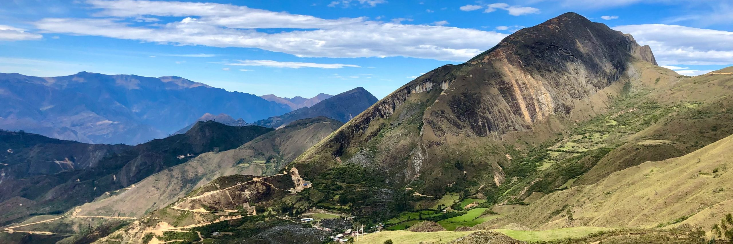
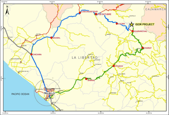
Igor is located in northern Perú in the Western Cordillera of the Andes, District of Huaranchal, Province of Otuzco, Department of La Libertad. Trujillo, a city of some 800,000 inhabitants, and the capital of La Libertad, serves as the point of departure when travelling to the project. Trujillo is 560 kilometres, a seven hour drive, or one hour flight, from Lima.

From Trujillo there are two routes to the project:

  1. 142 kilometres and approximately five and half hours – Trujillo – Chicama – Cascas – Lucma – Igor.
  2. 174 kilometres and approximately six hours – Trujillo – Otuzco – Charat – Huaranchal – Igor.

Elevations on the project range from 2800 to 3800 metres. There are two main seasons: a rainy season from December to April when road access is typically slower, and a dry season from May to November.

REGIONAL GEOLOGY

The Igor Project is located on the central spine of the Western Cordillera of the Peruvian Andes. The regional geology consists of the Lower Cretaceous Chimú Formation (quartz arenite, black shale and local coal seams) overlying shale and intercalated sandstone, quartzite and mudstone of the Upper Jurassic Chicama Formation. Intermediate to felsic intrusive rocks of Mid to late Tertiary age are common and responsible for most of the significant mineral deposits in the area.

Metallogenically, the Igor Project is part of the Oligocene – Pliocene Gold-Silver Epithermal Belt. Important deposits are Yanacocha, Shahuindo, La Arena and Sayapullo to the north, while to the south lie Lagunas Norte, Salpo, Quiruvilca, Pashpap and Pierina. To the east, lies the Miocene Gold-Copper Porphyry Belt, which includes deposits such as Minas Conga, El Galeno and Magistral.

The original Igor and Tesoros mines are included in a group of disseminated gold deposits, found in the Cajabamba-Huamachuco-Angasmarca (CHA) region of northern Peru, known as distal sandstone-hosted gold deposits (Montoya, et al., 1995). The Shahuindo and La Arena gold and silver deposits are nearby examples of this deposit type. The Igor project exhibits most of the major sandstone-hosted gold deposit characteristics including: host rock lithology, structural setting, hydrothermal alteration, and geochemistry. This large scale, potentially bulk minable target type has not seen significant exploration focus in the past at Igor, but it is an important exploration target for PPX. Our geologists believe that the Portachuelos target area also shares these same geologic characteristics.

PPX Mining will concentrate on the expansion and development of the Callanquitas structurally-controlled high-grade gold and silver mineralization while simultaneously evaluating the potential for bulk-mineable, low-grade gold and silver mineralization at Tesoros and Portachuelos, targets that could greatly expand the precious metal resource base at Igor.  It is clear that the Igor Project is a district scale project with the potential for multiple gold and silver deposits.

LOCAL GEOLOGY

The main rock types at Igor are:

  • Quartzite, arenite and shale of the Chimú Formation.
  • Arenite, quartzite and carbonaceous shale with syngenetic pyrite in the underlying Chicama Formation.

The sedimentary sequence has been extensively folded, thrusted and dissected by major faults. The structure is dominated by an anticline some 3 kilometres (km) long and 2 km wide.  Intruding the sedimentary rocks are numerous dacitic dykes, stocks and sills that are typically altered to a phyllic hydrothermal assemblage (quartz-sericite-pyrite). Minor granodiorite is present some deep drill holes.

Precious metal mineralization at Igor consists of a series of veins, breccias and mantos principally with a north to south orientation, although secondary north-east to south-west and north-west to south-east trends are also important. Gold and silver are the most important metals. Geochemically, arsenic and antimony commonly accompany precious metal mineralization.  Weak localized base metal (lead and zinc) mineralization is also present. Copper grades are generally low, but frequently increase with depth, especially in the Portachuelos area. Oxidation, especially along structures, is pervasive and commonly extends to depths of several hundred metres. Gold and silver mineralization appears to bel ow to Intermediate sulphidation epithermal in character and there are indications of a deep porphyry copper gold system underlying the Igor District.

Igor contains a district scale scale hydrothermal system with four principal gold and silver mineralized areas or deposits:

  • Callanquitas: Gold and silver mineralization consists of a series of north-south striking, structures over a zone some 900 metres long and 200 to 300 metres wide. Mineralization is open to the north, south and at depth.  Mineralization is characterized by thick zones of tectonic and hydrothermal breccia that host gold and silver mineralization within which are discrete, continuous zones with very high grades, e.g. diamond drill hole CA-17-86, 3.3m grading 27.72 gpt Au and 242 gpt Ag (30.97 gpt Au Eq). The December, 2012 NI 43-101 Technical Report describes this area in detail.
  • Domo: A zone of bedding-parallel mantos and perpendicular veins along the crest of the southeast end of the Igor Anticline. Precious metal mineralization is controlled by a series of northeast-southwest trending faults.
  • Tesoros: A system of veins, breccias and mantos along a major north-northeast striking fault that has localized the emplacement of dacitic porphyries and pebble dykes.  Historic drill hole 9d cut 75.2m grading 3.1 gpt Au and 109 gpt Ag (4.55 gpt Au Eq), emphasizing the potential for good grade, potentially bulk minable, gold and silver mineralization in the Tesoros area.
  • Portachuelos:  The Portachuelos discovery is located over 800 metres south of the existing Callanquitas resource and represents a new area of shallow, lower grade gold and silver mineralization hosted by tectonic and hydrothermal breccia. The Portachuelos mineralized zone has a strike length of approximately 650 metres, a true thickness of up to 40 metres and has been drilled to a depth of 130 metres. The gold and silver mineralization at Portachuelos is open in all directions, vertically and laterally.  Diamond drill hole CA-18-94 intercepted 40.2 metres grading 1.18 gpt Au, 115.4 gpt Ag, (2.72 gpt Au Eq) at a vertical depth of only 25 metres, highlights the resource potential of this area.
 

LOCAL GEOLOGY

PPX Mining Corp. acquired and started work at Igor in June 2005. Over the next three years, the company mapped and took approximately 3100 rock and 250 soil samples. Based on this data, three separate drill campaigns were undertaken, largely focused on the Domo and Tesoros areas, but with some exploratory drilling elsewhere. A NI 43-101 compliant resource for the Domo and Tesoros was prepared in early 2008; however this Technical Report is out of date and is not relied upon or referenced by the company.

In 2008, exploratory drilling outside the Domo and Tesoros areas intercepted significant gold and silver mineralization. At Callanquitas, drill hole CA-01b cut 218 metres (m) grading 0.6 g/t gold and 22.3 g/t Ag. This included 27.3 metres at 2.1 g/t gold and 35.4 g/t silver. The hole finished at 230.7 metres with an interval of 2 metres grading 1.7 g/t gold, 61.8 g/t Ag and 0.44 % copper. The presence of copper mineralization, along with porphyry-type hydrothermal alteration, indicated that Igor may be underlain by a porphyry copper deposit.

In 2010 PPX resumed work with a drill campaign of 2,500 metres at Callanquitas. The goal of this program was to further delineate near-surface oxide gold and silver mineralization, first identified in 2008. The original five drill hole campaign was completed in early March 2011, but encouraging results and reinterpretation of the geological model led to three more holes. The extended campaign finished in early May 2011 with a total of 4,235 metres of diamond drilling. The Callanquitas drill campaign was highly successful. It defined a main structure approximately 5-20 metres wide, 900 metres long, extending from surface to a depth of 300-400 metres. The intersections include some high grade gold and silver, with multi-kilogram silver grades. The mineralization was open to the north, south and at depth. This structure is one of several north-south trending mineralized structures at Callanquitas.

Following the success of the 2010-2011 drilling campaign, PPX Mining Corp. initiated detailed mapping and sampling of the Callanquitas Structure. Drilling during 2012 was focused on higher grade zones, particularly in the central sector of the Callanquitas Structure, with the goal of extending the mineralization at depth. This work culminated in a NI 43-101 compliant resource estimate and Technical Report for the Callanquitas Structure in December, 2012 (Please see : “Technical Report on the Callanquitas Structure, Igor Mine Project, Northern Peru, South America, NI 43-101 Technical Report” dated 14 December, 2012, as amended September 27, 2013. The technical report has been filed on SEDAR and is available on the Company’s web site.  Mineral resources are not mineral reserves and do not have demonstrated economic viability. There is no certainty that all or any part of the mineral resource will be converted into mineral reserves.

Drilling resumed at the Igor Project during 2017 with a Phase One, 6,000 metre diamond drilling program utilizing two drill rigs.  The drilling was subdivided into two separate campaigns:  The first, focusing on in-fill and resource expansion drilling within the Callanquitas resource area and a second campaign dedicated to drill testing the Domo, Tesoros, and Portachuelos exploration targets.  The drilling program was, and continues to be, very successful, outlining very high grade gold and silver mineralized “shoots” with excellent continuity at Callanquitas and discovering a new, shallow, potentially bulk-minable, mineralized zone at Portachuelos.  Drilling at Tesoros and Domo is upcoming during 2018.  A summary of drill results from the 2017-18 Phase One program are in the Technical Information section below.

The in-fill  and resource expansion drilling at Callanquitas is being conducted as part of a Pre Feasibility Study (“PFS”) evaluating mine development and processing options for the Callanquitas resource.  In parallel with the diamond drilling program, an underground test mining and bulk sampling program, described in the following section, is also underway.  Highlights of the diamond drilling program include drill hole CA-17-86 which cut 12.6m grading 8.34 gpt Au and 207 gpt Ag (11.10 gpt Au Eq) including 3.3m grading 27.72 gpt Au and 242 gpt Ag (30.97 gpt Au Eq), and drill hole CA-17-87 that intercepted 5.5m grading 8.46 gpt Au and 104 gpt Ag (9.85 gpt Au Eq) including 2.0m grading17.41 gpt Au and 200 gpt Ag (20.08 gpt Au Eq).  Cross sections and a long section illustrating these and other recently completed drill holes are shown in the Technical Informationsection below.

Drilling in late 2017 and early 2018 discovered a new, shallow, lower grade gold and silver mineralized zone at Portachuelos, 800 metres south of the Callanquitas resource.  The Portachuelos mineralized zone has a minimum strike length of approximately 650 metres, a true thickness of up to 40 metres and has been drilled to a depth of 130 metres. The gold and silver mineralization at Portachuelos is open in all directions, vertically and laterally.  Mineralization is hosted by tectonic and hydrothermal breccia along a north-northwest trending zone.  Diamond core drill hole CA-18-94 has intercepted 40.2 metres grading 1.18 gpt Au, 115.4 gpt Ag, (2.72 gpt Au Eq) at a vertical depth of approximately 25 metres and highlights the significance of this discovery.  A cross section and maps depicting the Portachuelos area can be found in the Technical Information section.